Map Chart

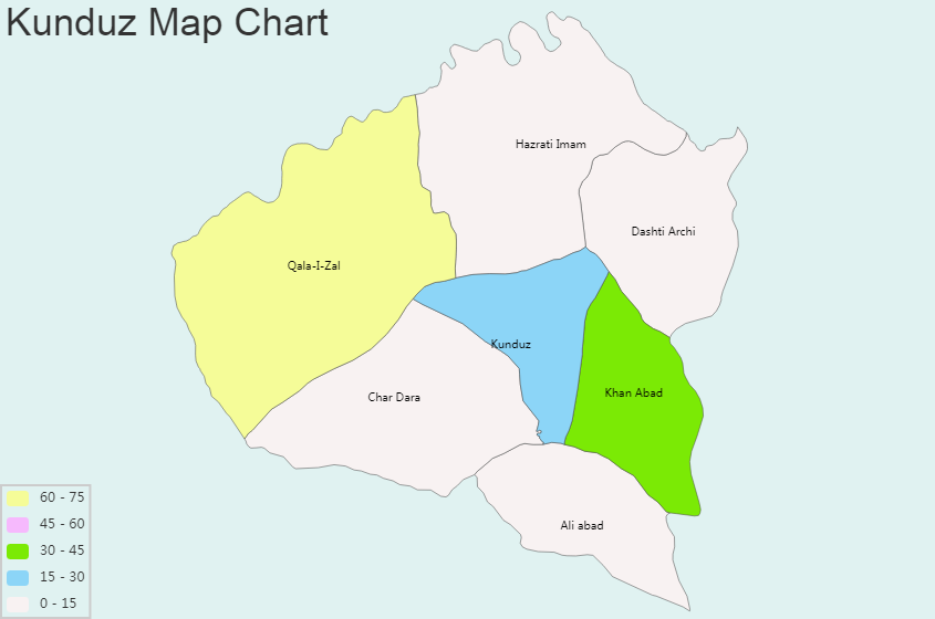
Kunduz Map Chart and Blank Image

General Information of Kunduz: Coordinates: 36°43′43″N 68°52′5″E Country: Afghanistan Province: Kunduz Province District: Kunduz District First mention: 329 BC Elevation: 391 m (1,283 ft) Population (2012) – City: 268,893 – Urban: 268,893 Time zone: UTC+4:30 (Afghanistan Standard Time) Climate: BSk Kunduz bordering Province: Baghlan, Balkh, Samangan, Takhar Regional Maps: Map of Afghanistan, Map of Asia […]

Kunar Map Chart and Blank Image

General Information of Kunar: Coordinates: 35.0°N 71.2°E Country: Afghanistan Capital: Asadabad Government – Governor: Wahidullah Kalimzai Area – Total: 4,339 km2 (1,675 sq mi) 5556 Population[1] – Total: 428,800 – Density: 99/km2 (260/sq mi) Time zone: UTC+4:30 ISO 3166 code: AF-KNR Kunar bordering Province: Laghman, Nangarhar, Nuristan Regional Maps: Map of Afghanistan, Map of Asia Kunar […]

Khost Map Chart and Blank Image

General Information of Khost: Coordinates: 33°19′59″N 69°55′01″E Country: Afghanistan Province: Khost Province District: Khost District Elevation: 1,225 m (4,019 ft) Population (2006) – City: 160,214 – Urban: 106,083 Time zone: UTC+4:30 (Afghanistan Standard Time) Khost bordering Province: Paktika, Paktya Regional Maps: Map of Afghanistan, Map of Asia Khost province is divided into districts: Khost (Matun), Mando Zayi, Musa Khel, […]

Kapisa Map Chart and Blank Image

General Information of Kapisa: Coordinates (Capital): 35.0°N 69.7°E Country: Afghanistan Capital: Mahmud-i-Raqi Largest city: Nijrab Government – Governor: Syed Mohammad Khalid Hashimi – Deputy Governor: Mohammad Nabi Safi Area – Total: 1,842.1 km2 (711.2 sq mi) Population (2015)[1] – Total: 441,010 – Density: 240/km2 (620/sq mi) Time zone: UTC+4:30 ISO 3166 code: AF-KAP Main languages: […]

Kandahar Map Chart and Blank Image

General Information of Kandahar:Coordinates: 31°37′N 65°43′ECountry: AfghanistanProvince: KandaharDistrict: KandaharGovernment • Mayor: Rokhan WolasmalArea • Total: 273.37 km2 (105.55 sq mi)Elevation: 1,010 m (3,310 ft)Population (2015) • Total: 557,118Time zone: UTC+4:30 (Afghanistan Standard Time) Kandahar bordering Province: Hilmand, Uruzgan, Zabul Regional Maps: Map of Afghanistan, Map of Asia Kandahar province is divided into districts: Arghandab, Arghistan, Daman, Ghorak, Kandahar City, Khakrez, Maruf, […]

Kabul Map Chart and Blank Image

General Information of Kabul: Coordinates: 34°32′N 69°10′E Country: Afghanistan Province: Kabul No. of districts: 22 Capital formation: 1776 Government – Type: Municipality – Mayor: Muhammad Yunus Nawandish Elevation: 1,791 m (5,876 ft) – Total: 4,600,000 Demonyms: Kabuli, Kabulite Time zone: UTC+4:30 (Afghanistan Standard Time) Postal code:  100X, 101X, 105X, 106X Area code(s): (+93) 20 HDI […]

Jawzjan Map Chart and Blank Image

General Information of Jawzjan: Coordinates: 36.75°N 66.00°E Country: Afghanistan Capital: Sheberghan Government – Governor: Maulvi Lutfullah Azizi Area – Total: 11,798.3 km2 (4,555.3 sq mi) Population (2015) – Total: 540,255 – Density: 46/km2 (120/sq mi) Time zone: UTC+4:30 ISO 3166 code: AF-JOW Main languages: Dari, Uzbek, Turkmen Jawzjan bordering Province: Balkh, Faryab, Sari Pul Regional Maps: Map […]

Hirat Map Chart and Blank Image

General Information of Hirat: Coordinates: 34°20′31″N 62°12′11″E Country: Afghanistan Province: Herat Area – Total: 182 km2 (70 sq mi) Elevation: 920 m (3,020 ft) Population – Total: 436,300 – Density: 2,400/km2 (6,200/sq mi) Time zone: UTC+4:30 (Afghanistan Standard Time) Climate: BSk Hirat bordering Province: Badghis, Farah, Ghor Regional Maps: Map of Afghanistan, Map of Asia Hirat province is […]

Hilmand Map Chart and Blank Image

General Information of Hilmand: Coordinates (Capital): 31.0°N 64.0°E Country: Afghanistan Capital: Lashkar Gah Government – Governor: Hayatullah Hayat Area – Total: 58,584 km2 (22,619 sq mi) Population (2013) – Total: 879,500 – Density: 15/km2 (39/sq mi) Time zone: UTC+4:30 ISO 3166 code: AF-HEL Main languages: Pashto & Balochi Hilmand bordering Province: Farah, Ghor, Kandahar, Nimroz, Uruzgan Regional […]

Ghor Map Chart and Blank Image

General Information of Ghor: Coordinates (Capital): 34°N 65°E Country: Afghanistan Capital: Firuzkoh Government – Governor: Ghulam Nasir Khaze Area – Total: 36,478.8 km2 (14,084.5 sq mi) Population (2015) – Total: 700,296 – Density: 19/km2 (50/sq mi) Time zone: UTC+4:30 ISO 3166 code: AF-GHO Main languages: Hazaragi, Dari, Pashto Ghor bordering Province: Badghis, Bamyan, Farah, Faryab, Hilmand, Hirat, […]

Lihat Postingan Lainnya