Botswana Map in Africa

Regional Maps: Map of Africa, World Map
Map Location

Black and white Map

Map Blank White

Map Blank Color

Important city of Botswana: Bogogobo, Dutlwe, Francistown, Gaborone, Ghanzi, Gweta, Hukuntsi, Jwaneng, Kang, Kasane, Kayne, Khudumelapye, Khuis, Lobatse, Mahalapye, Makalamabedi, Mamuno, Maun, Mochudi, Molepolole, Mosetse, Muhembo, Nata, Orapa, Palapye, Rakops, Ramotswa, Sebina, Selebi Phikwe, Serowe, Shadawe, Shorobe, Toteng, Tsau, Tshabong, Tshane, Tshootsha and Werda.
Thing to Know
.tg {border-collapse:collapse;border-spacing:0;border:none;} .tg td{font-family:Arial, sans-serif;font-size:14px;padding:10px 5px;border-style:solid;border-width:0px;overflow:hidden;word-break:normal;} .tg th{font-family:Arial, sans-serif;font-size:14px;font-weight:normal;padding:10px 5px;border-style:solid;border-width:0px;overflow:hidden;word-break:normal;} .tg .tg-x5q1{font-size:16px;text-align:left;vertical-align:top} @media screen and (max-width: 767px) {.tg {width: auto !important;}.tg col {width: auto !important;}.tg-wrap {overflow-x: auto;-webkit-overflow-scrolling: touch;}}
| Continent | Africa |
| Region | Southern Africa |
| Coordinates | 22°00′S 24°00′E |
| Area | Ranked 48th |
| • Total | 581,730 km2 (224,610 sq mi) |
| • Land | 97.42% |
| • Water | 2.58% |
| Coastline | 0 km (0 mi) |
| Borders | Total land borders: 4,374.15 km (2,717.97 mi) |
| Namibia: 1,544 km (959 mi) | |
| South Africa: 1,969 km (1,223 mi) | |
| Zambia: 0.15 km (0.093 mi) | |
| Zimbabwe: 834 km (518 mi) | |
| Highest point | Tsodilo Hills 1,489 m (4,885 ft) |
| Lowest point | Junction of the Limpopo and Shashe Rivers 513 m (1,683 ft) |
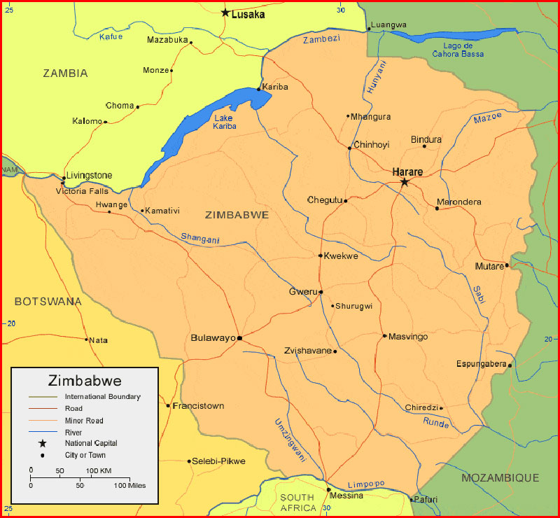
Baca juga: Zimbabwe Map Africa High Resolution
Nama asli saya Supriyadi dan populer Supriyadi Pro. Saya seorang Expert wordpress developer freelancer, content writer, editor. Memiliki minat besar pada dunia teknologi, sains, seni budaya, social media, dan blogging. Saya kelahiran suku Jawa, di Wonogiri, Jawa Tengah yang ahli bahasa Jawa dan seni gamelan. Silahkan hubungi saya lewat laman yang telah disediakan.