United Kingdom Map High Resolution

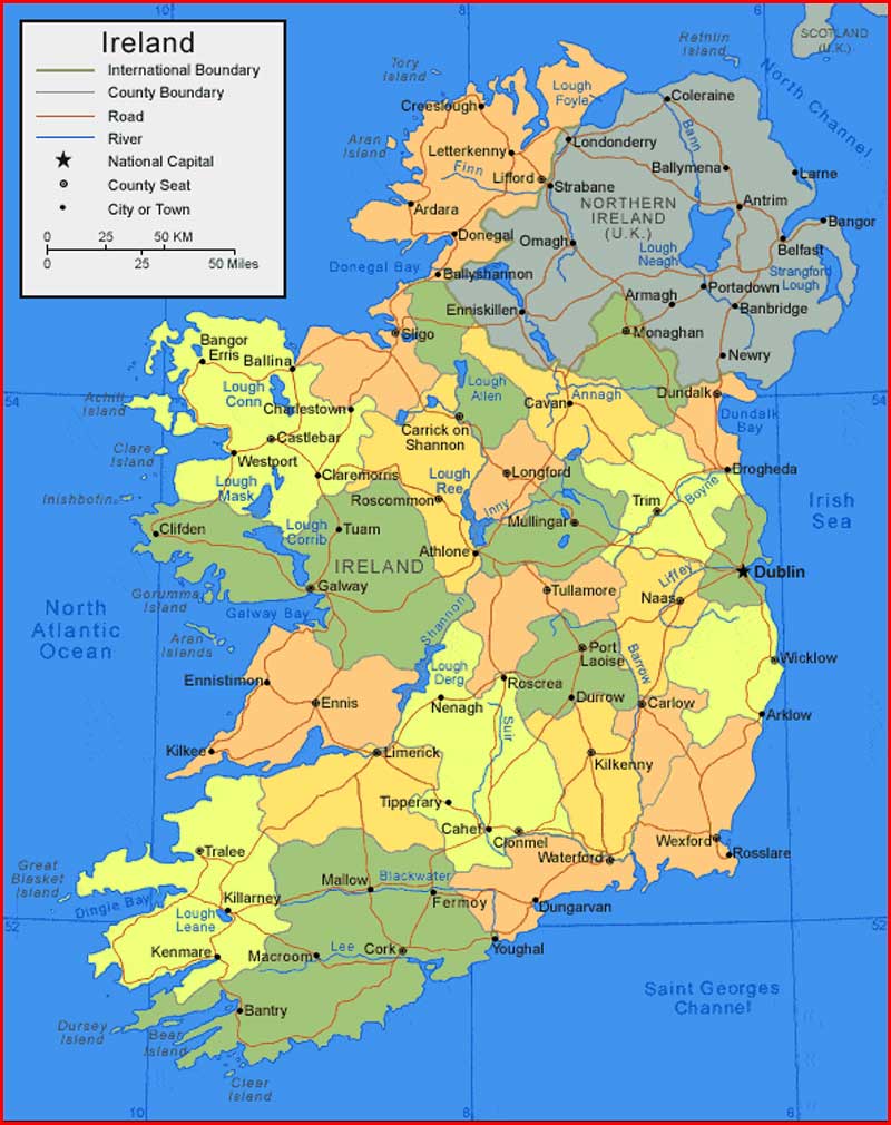
United Kingdom Bordering Countries: Ireland
Regional Maps: Map of Europe, World Map
Countries in map: England, Scotland, Northern Ireland, Wales
Political map

Map location

Important city of United Kingdom: Aberdeen, Aberystwyth, Antrim, Armagh, Ayr, Ballycastle, Barnsley, Barrow-in-Furness, Bath, Belfast, Birmingham, Blackpool, Bournemouth, Bradford, Brighton, Bristol, Caernarfon, Cambridge, Canterbury, Cardiff, Carlisle, Carmarthen, Chelmsford, Cheltenham, Chester, Chichester, Coleraine, Cookstown, Coventry, Cupar, Derby, Doncaster, Dorchester, Dover, Downpatrick, Dumfries, Dundee, Durham, Edinburgh, Exeter, Falkirk, Fishguard, Fort William, Glasgow, Gloucester, Grimsby, Hamilton, Hastings, Hereford, Holyhead, Inverness, Ipswich, King’s Lynn, Kingston upon Hull, Kirkcaldy, Kirkwall, Larne, Leeds, Leicester, Lerwick, Lewes, Lincoln, Liverpool, London, Londonderry, Luton, Maidstone, Manchester, Mansfield, Matlock, Middlesbrough, Mold, Motherwell, Newcastle upon Tyne, Newport, Newry, Newton Saint Boswells, Northallerton, Northampton, Norwich, Nottingham, Oban, Oxford, Penzance, Perth, Peterborough, Plymouth, Portsmouth, Preston, Reading, Reigate, Saint Andrews, Salisbury, Scarborough, Sheffield, Shrewsbury, South Shields, Southampton, Southend-on-Sea, Stafford, Stockport, Stoke-on-Trent, Stornoway, Stranraer, Stratford-upon-Avon, Stroud, Sunderland, Swansea, Thurso, Torbay, Trowbridge, Truro, Ullapool, Wakefield, Warwick, West Bromwich, Weymouth, Winchester, Wolverhampton, Wokingham, Workington, and York.
Nama asli saya Supriyadi dan populer Supriyadi Pro. Saya seorang Expert wordpress developer freelancer, content writer, editor. Memiliki minat besar pada dunia teknologi, sains, seni budaya, social media, dan blogging. Saya kelahiran suku Jawa, di Wonogiri, Jawa Tengah yang ahli bahasa Jawa dan seni gamelan. Silahkan hubungi saya lewat laman yang telah disediakan.
Artikel Terkait